Dr. Matt Nolan
Institute of Northern Engineering
University of Alaska Fairbanks
|
Dr. Matt Nolan
Institute of Northern Engineering |
|
|
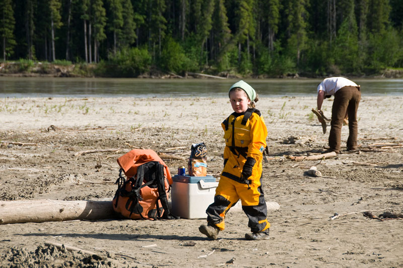
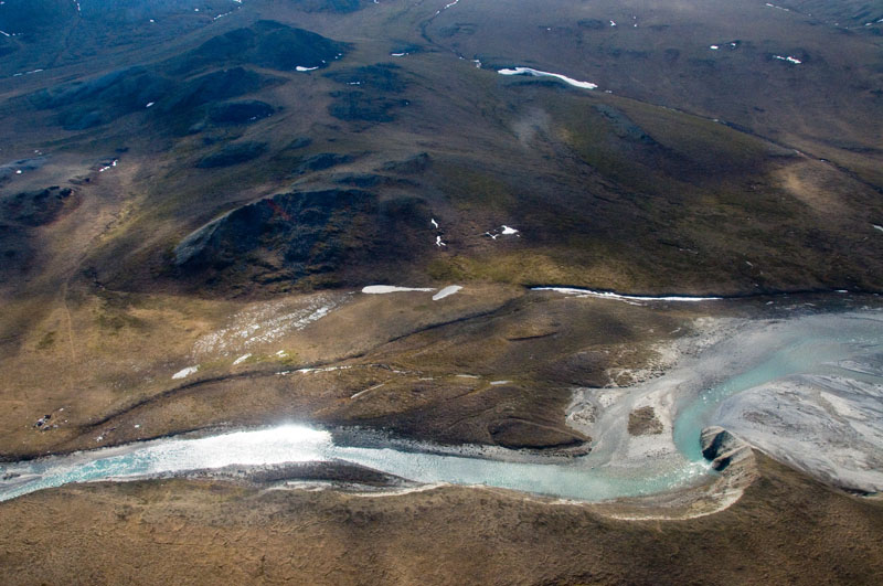
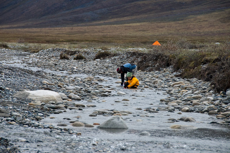
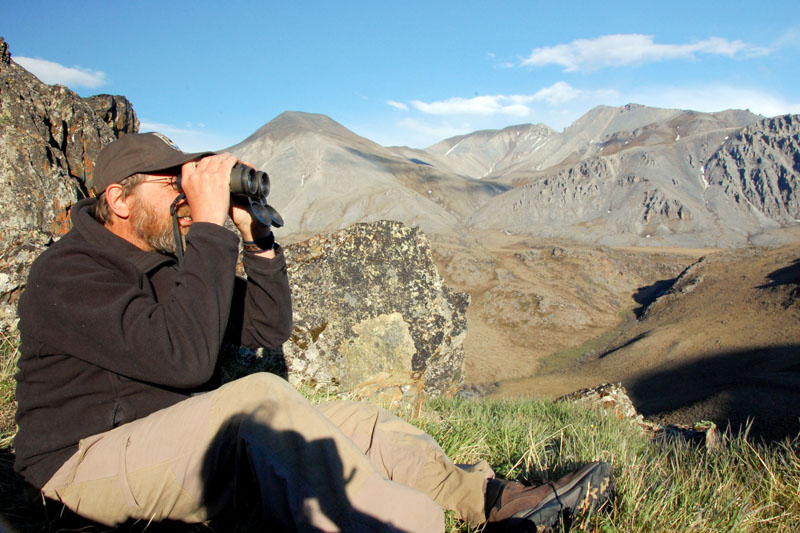
28 June 2011 Fairbanks Well, where to begin on our exploits of the past few weeks, other than to say the trip did not go as planned... Our goal on this trip was to float the Hulahula River and assess the feasibility of conducting science from a boat-based platform. With us were Greta Burkart, an aquatic ecologist looking for bugs, Cameron Baird, a river guide looking for water, Dave Payer, lead ecologist of the Arctic Refuge looking for scientists, Andre, a semi-illegal alien from Ukraine looking for adventure, and a dog named Jesus, looking for a stick. The general idea was that Greta, Dave, Cameron and I would float down from Grasser's airstrip and meet up with Kristin, Turner, and Andre at Fish Hole 2, where Dre and Jesus would leave us and the rest would float to the coast. Along the way, the plan was that Cameron would teach me something about boating, Greta would teach me something about bugs, and Dave would teach me something about ecology and management. I saw this trip largely as a shake-down for me in preparation for a much more scientifically-ambitious trip in August down the same river, as well as perhaps future trips. I had bought a boat several years ago in preparation for this sort of work, but had never really used it beyond some tests, so there was some learning curve for me. I had been talking with Michael Wald, who runs a guiding outfit in the Arctic called Arctic Wild, for a number of years about doing something together, and he provided us with one of his guides, Cameron, to help get me up to speed in running my own river trips safely and sanely. I had also asked Michael to prepare our food and kitchen gear, so that I could get a better sense of how other handle this, as no doubt it's different than how we do things for glacier trips, and this fortunately saved us a lot of preparation time. This trip was due to begin about June 9, a bit more than two weeks after our return from McCall Glacier for several weeks. So there was little time to relax afterwards and gear went straight from regular backpacks into dry bags. We had hoped during this time to do some aerial photography of the rivers here as well, but unfortunately the aircraft (or rather than FAA) was not cooperating, so there was constantly another project hanging over our heads during float trip preparation. I tried to front load the float trip preparations so that if the aerial photography materialized it wouldnt leave us stuck, but in the end it never did, and a number of tasks cropped up that had to be dealt with anyway. One of them was getting a proposal funded through USFWS for the studies we were doing on this float trip, which I was funding through a combination of slush funds and personal funds just to get it done, and despite the simplicity of the process there were numerous small paperwork issues that needed to be resolved and took time away from drinking beer. Or at least with my feet up. On the personal side, we also had some shake-down work to do. We put a lot of time into making sure Turner learned to swim over the winter, and it seemed now that he was pretty comfortable with it. We also bought him a dry suit, so that in case he fell off the boat he would stay warm and dry while finding a place to stand. We had all of our personal and science gear packed the weekend before and went for a float down the Chena River on Memorial Day, along with half of Fairbanks. A few days later we went out with Michael and his family in their boat on the Tanana River. It was really nice to see Turner having fun with their kids, and an amusement to me too see his kids swimming naked in the river with mine wearing a dry suit. It was also clear to me that we dont spend nearly enough time with evening and afternoon outings like this, though I find it hard to complain as we do spend several months per year in the middle of nowhere. This again turned out to be one of those trips with no real beginning, as everyone was showing up from different locations and joining at different times. The Nolans flew in to Deadhorse several days before the trip start, hoping to get some aerial photography done. Unfortunately the weather was uncooperative, so we mostly sorted gear and dealt with minor issues. Dave was at Galbraith Lake, finishing up a another project, and hoping a Refuge pilot would take him directly to the river. Greta and Cameron were in Fairbanks, planning to fly commercially to Deadhorse in the early morning. All was in flux though on the day of the put-in, as the day before Fairbanks was shut down due to thick smoke from forest fires and the Alaska Airlines flight to Deadhorse was up on indefinite hold due to mechanical problems. We decided to wait to go in ourselves until we saw how things would play out with the others, since I was going to a different location than Kristin and Turner, and there was some debate about the trip itself working out even if everyone was ready. Bob flew a gear load out to Grassers the day before out put-in to speed things along, and reported that he met Robert Thomson out there who was thinking about cancelling his float trip due to low water, which was a somewhat ominous sign. In any case, Fairbanks opened up and Dave was the first to get to the put-in location, and by evening Greta, Cameron, and I were also there. As Robert had reported, there wasnt much water in the river, and one could easily walk across in knee boots or crocs. We spent the evening regrouping, hanging out with Robert, and strategerizing for science. There was a strong upvalley wind, which let up around 10PM, as Robert said it had for the past several nights. I was unconvinced that it was a true valley wind, caused by the air heating and lifting due to the warm sunlit rocks of the valley walls, but after several days of this it was hard to argue with. Still, we never saw this in the Jago Valley, and I think there is more to the story than the textbook model. We spent that next day in the wind, setting up boats, chatting more with Robert, shaking down science gear and protocols, and waiting for the wind to die down. We decided to load the boats and have a late dinner hoping that the wind would die down as they had in the past. By 9PM there wasnt much left to do except pack and go, and I felt pretty pathetic as a glaciologist changing into my dry suit in the cook tent because it was too cold to change outside. But with the suit on, I was a superhero, impervious to the elements and toasty warm, though again feeling pretty pathetic when I wiped out on a cut bank and landed on my rib cage. In any event, by 10PM or so we were on our way. Or at least on our way to the first dragging location about 20 meters downstream... The water was low. Like really low. So low you could easily walk across it without getting up to your knees. And it was really clear, so you could see the rocks at the bottom and place your foot where you wanted. Unfortunately the boats had fewer options. Many small rocks were sticking up out of the water, so no matter how shallow your draft, you could not help avoiding scraping or getting hung up. After a few hundred meters, we reduced our goals from getting the 8 miles we had hoped to just getting out of sight of Robert, who was no doubt already preparing his story about the crazy white guys that thought they could walk on water all the way to the coast. It turned out that the beginning stretch was the worst of it, but we had no way of knowing this. The wind had died to flat calm and it was a perfect temperature with no bugs, so despite being late at night and having no water to float it, it was a beautiful evening. I'm sure on all of our minds was wondering at what point the glaciers were going to start melting again and bring water levels up to floatable levels, and whether it made more sense to wait for that or to keep slogging it out. In any case, we kept slogging it out. After an hour or two, Greta and I stopped trying to get back into the boats and just walked. Our pace was about the same as the boats, as without us they floated better and got hung up less, and we caught up where four people were required to drag, which was often enough. As float trips go, it sucked, but as hiking trips go it was great. To walk out here with no backpack or bugs was a real joy, and river crossings were a non-issue with the low water and dry suits. So we continued on like this all night. Everyone remained in great spirits throughout, and with the weather so nice and our goal in sight taunting us there seemed no compelling reasons to stop. Clearly at least some of us were being driven by the testosterone of an epic story in the making and the ability to say that we made it all the way to the East Patuk strip despite having to walk it all, though I think had any one person been intelligent enough to say "let's camp here" there would have been no arguments. In the last half mile or so the river became more channelized, and Greta and I hopped on the boat whenever possible. My feet were raw simply because my dry suit socks kept bunching up and sucking my entire suit into my boots, causing me to walk like a zombie within a few minutes of pulling off my boots and resetting everything. By 5AM, we were all starting to feel like zombies, but fortunately within half an hour or so we were pulled up near the airstrip. This was the last real strip before Fish Hole 2, where Kristin, Turner, Andre, and Jesus now were, which was 20 miles away. So making it to here gave us options, but once past here we were committed to several days of dragging if conditions didnt improve. We pulled up just upstream of where the East Patuk river enters the Hulahula, a few hundred meters upstream of the airstrip and the traditional camping spot. But between here there were a series of riffles that would require 4-person dragging, and the lure of willows surrounding this spot was too much to fight, so technically we didnt actually make it to the airstrip. I didnt bother setting up a tent, I just laid out my pad on the north side of an incline of an old cut bank beneath some willows and fell asleep to the sound of tent stakes been hammered in. I woke up about 10AM to check in with Kristin via sat phone, and the winds had not yet picked up. They were all doing well, though Jesus wasnt sleeping well due to the cold. I fell back asleep for a few hours and awoke with a bit of a sunburn and the winds in full force, though fortunately just a gentle breeze where my bag was situated. We had a slow afternoon, not really sure whether to eat breakfast lunch or dinner at 5PM, but managed to get some science done nonetheless. Greta collected invertebrates and water samples, while I gaged the river, with Dave helping us both and Cameron scouting the lower river. By 10PM we had packed up and eaten a meal we still werent sure what to call, and stoodby waiting for the winds to die to so that we could launch. We figured that as we went downstream, the tributaries would increase water levels and that the river would be more channelized. Perhaps it was all wishful thinking, but at this point we were on a roll and probably thinking more of future epic stories to tell than about reality. One thing we all agreed on was that we werent going to try this when the wind was blowing strong against us. So we sat in our little hole out of the wind chatting and nibbling, watching the cloud and fog rip into the valley just in front of us. By 1AM it had barely let up and a bottle of rum emerged mysteriously. By 2AM the bottle was mostly empty and the winds were beginning to let up, but it was clear at this point that our floating/draggin adventure was over. Given the distance we had to cover, we would need two full nights of dragging to get there, not just a few hours per night. And with this change in weather pattern, it wasnt clear how much if any time we would have wind-free. And with all of our time spent dragging, there would be little left for science along the way. So short of a huge pulse of glacier melt in the morning, it looked like we were flying out. Scientifically, we had several projects. Greta's main goal was to sample aquatic invertebrates, essentially the larva of the flying bugs that pester us once they turn airborne. These live in the water and rocks underneath it, 27 December 2011 Fairbanks Obviously I need to finish the story at some point. The short version is that we flew from East Patuk to Fish Hole 2, spent a few days working there, then Greta and the Nolans flew over the Jago River and spent a few days working there.
Spherical
Panoramas
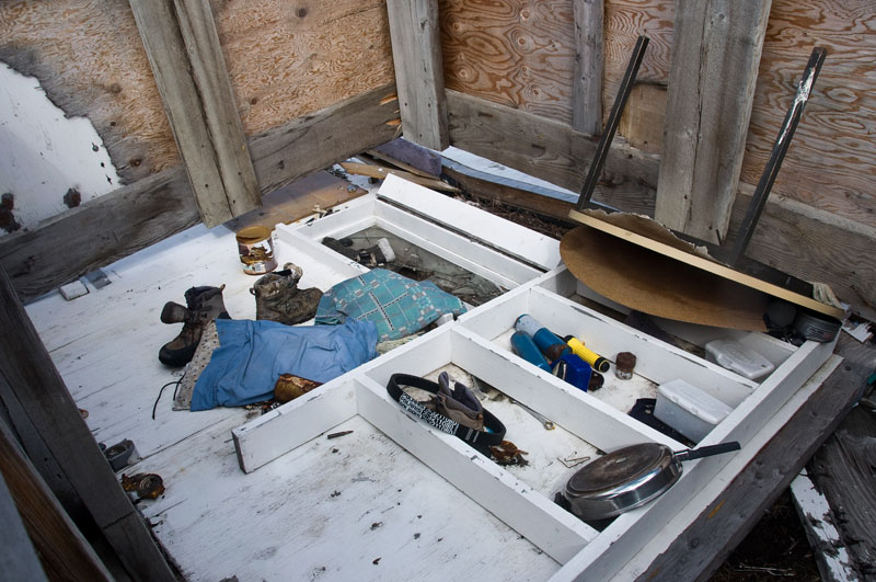
Cabins near 2nd Fish Hole There are few cabins built and used by locals from the Kaktovik near the fish hole. They are accessed by them only by snow machine in winter. As can be seen, they are quite an eyesore. I know a lot of the people that use or own these, and I sympathize a bit with their plight, but not very much. As can be seen, nearly all of the trash has been plinked with a .22, so it's not like it's buried by snow in winter, and only locals use .22-250s up here. It's hard to take local claims of being ecologically better stewards of the land than non-locals when this trash heap is allowed to grow each year, and everyone in Kaktovik knows about it. Not that it should matter, but making the situation worse is that these cabins are not built on an inholding, so this Federal land owned by all of us. The Kaktovik inholding in this area is actually across the river and is unused. If it werent for this shit hole, I'd say this is one of the most scenic spots in Alaska.
Greta Burkart's Photos
|
(c) 2010 Matt Nolan.