The start of five months of research on McCall Glacier
In about 48 hours we leave Fairbanks
for five months of research on McCall Glacier and its neighbors in the
Alaskan Arctic. For the past few months we have been making plans,
shipping tons of gear, and looking forward to an exciting field season.
As usual with any big project, we have encountered numerous obstacles,
delays, set-backs, and triumphs. But the preparations are nearly
finished now and were ready to face the next set of challenges.
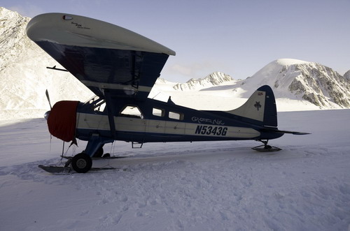
All of our field logistics are handled by small fixed wing aircraft,
like this Beaver flown by Dirk Nickisch. This photo was taken a few weeks
ago when we confirmed there was enough snow to land and marked out a runway
for later gear shuttles.
The field season consists of several large, independent efforts, in addition to a many smaller process studies. More than dozen scientists from 4 countries and numerous universities and research facilities are participating; more on the participants later. Here is an outline of our goals and time-tables.
April 22- June 3: Ice core extraction and thermistor string installation. We plan to drill 3 deep holes, from 150 to 220 meters. We will extract about 180 meters of ice and fly this back to Fairbanks for temporary storage until it is analyzed later in fall. The bulk of the returned ice will come from the first hole, and will be flown back as soon as it is extracted, probably about May 7. Once the drilling is completed near the end of May, the drill and four of the field team will return home and four of us will remain until September. During the take-out, we will try to survey one or two other glaciers in the area on ski.
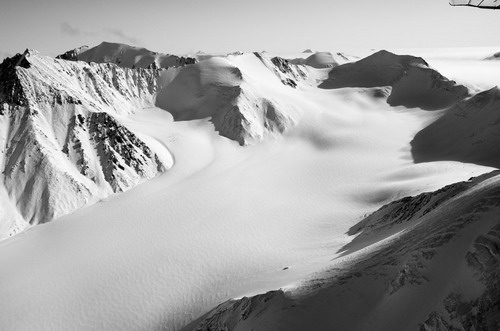
Okpilak Glacier, shown here in early April, is one of the glaciers
in the area that we often survey, by skiing down it with a differential
GPS unit on our backs.
June 3 June 31: Glacier studies. We begin a stream monitoring program at the terminus as well as conduct our basic mass balance and velocity studies and other process studies.
July 1 July 15: Airborne LIDAR DEM acquisition. A local mapping company will fly an airplane with a LIDAR to create a new topographic map of the eastern Brooks Range and the glaciers there. This map will allow us to calculate ice volume change of more than 400 glaciers and provide good base maps for future measurements and modeling. Some of the field team will leave the glacier (picked up via fixed wing from the ice or tundra, depending on conditions) and base from Kaktovik to assist with this effort, and the others will provide ground support, mostly in the form of GPS measurements.
July 16- 30: Stream surveys. Part of our project is to understand the impacts that thinning or disappearing glaciers have on the local ecology. Melt-water from storage keeps streams and rivers flowing stronger through summer than the otherwise would, plus keeps sediment supplies higher. By measuring discharge and water quality parameters in summer, we can get a better sense of baselines to judge future changes.
July 31- August 9: Installation of pollen traps. A team from the University of Southern Mississippi will come to the glacier to install a new weather station with pollen traps. These pollen traps and associated snow pit studies will allow us to build a better transfer function which will aid in ice core interpretation, here and elsewhere.
August 10-September 1: End of summer glacier studies. Hydrological monitoring and internal accumulation studies will continue until freeze-up.
September 1-7: Stream surveys. The remaining team members will re-survey the surrounding rivers and try to link up with a US Fish and Wildlife team studying fish and aquatic ecology downstream, either by hiking, floating, or airplane. The target date to return to civilization may change and be as late as September 15, depending on conditions. We may also leave the glacier early, depending on when freeze-up occurs.
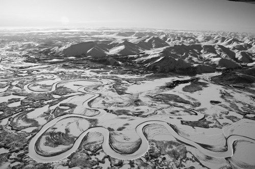
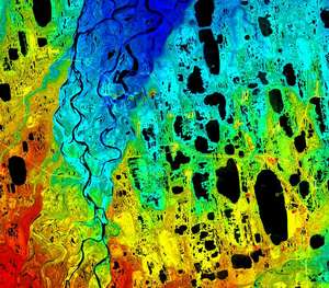
Rivers like these have higher flows in summer than they ‘should’,
due to meltwater from glacier volume loss.
If you want to learn more about
the area and some of our prior research in this area, I have compiled
a number of panoramic
photographs and airphotos of the area. Provided our internet
connection works in the field, I hope to post regular updates on our progress.
<-Previous Page Next page->