Dr. Matt Nolan
Institute of Northern Engineering
University of Alaska Fairbanks
|
|
Dr. Matt Nolan
Institute of Northern Engineering |
|
McCall Glacier IPY Lake El'gygytgyn IPY Virtual Globes IPY
|
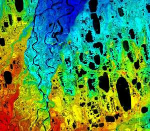
Research at the Kuparuk Watershed The Kuparuk River watershed enters into the Arctic Ocean near Prudhoe Bay, Alaska. It has the longest history of research of any basin within Arctic Alaska, as both the Toolik Lake and Imnavait Creek watersheds are part of this system. My efforts here have primarily been related to improving the digital elevation models of the area. We recently completed an NSF project to acquire, validate and distribute a new Star3i DEM of this area. In addition to validating the data in several ways, we also resampled the DEM to various resolutions and created numerous visualizations of the data. We documented all of our efforts in the html that accompanies the distribution package. You can view those pages here, along with the visualizations. We also produced a paper on related research within the Putuligayuk watershed, adjacent to the Kuparuk watershed. Here we used a new DEM to analyze many basic watershed characteristics. You can also view an overview of much of the research here. |
(c) 2003 Matt Nolan. If you find any broken links or other errors, please let me know. Thanks.